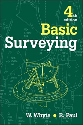
Basic Surveying (4th Edition) - Original PDF

دانلود کتاب Basic Surveying (4th Edition) - Original PDF

Author: Paul, Raymond, Whyte, Walter

0 (0)

توضیحات کتاب :

The primary aim of this book is to provide a guide to current practice and equipment for non-specialist surveyors in the various professions involved in the construction industry and the environment

سرچ در وردکت | سرچ در گودریدز | سرچ در اب بوکز | سرچ در آمازون | سرچ در گوگل بوک

1,281 بازدید 0 خرید

ضمانت بازگشت

ضمانت بازگشت

فایل های تست شده

فایل های تست شده

پرداخت آنلاین

پرداخت آنلاین

تضمین کیفیت

تضمین کیفیت

دانلود فوری

دانلود فوری

The primary aim of this book is to provide a guide to current practice and equipment for non-specialist surveyors in the various professions involved in the construction industry and the environment. It is suitable for students preparing for degrees and diplomas in architecture, building, building surveying, quantity surveying, estate management and town planning and environmental studies. It is also of value to engineers who are not specialising in engineering surveying.

This book has been thoroughly revised to include new topics such as OS digital mapping, standard deviation and standard error, global positioning systems, transition and vertical curves.

Walter Whyte was born in New Zealand of Scottish parents and educated in Scotland. He worked on site and building surveys in Scotland. He worked on site and building surveys in Scotland, then on road survey and setting out in the North Nyanza and Uasin Gishu Provinces of Kenya, and as a road engineer in British Southern Cameroons and Northern Nigeria, De Montford University in the UK and latterly at City University, Hong Kong.

Raymond E Paul has been professionally involved in surveying for over 40 years as a land and cartographical surveyor, senior lecturer and author. He has a wealth of practical experience and an awareness of the needs of the intended users of this book from all corners of the globe.

چکیده فارسی


هدف اصلی این کتاب ارائه راهنمای عمل و تجهیزات فعلی برای نقشه برداران غیرمتخصص در حرفه های مختلف درگیر در صنعت ساختمان و محیط زیست است. برای دانشجویانی که برای مقاطع تحصیلی و دیپلم در رشته های معماری، ساختمان، نقشه برداری ساختمان، نقشه برداری کمیت، مدیریت املاک و برنامه ریزی شهری و مطالعات محیطی آماده می شوند، مناسب است. همچنین برای مهندسانی که در نقشه برداری مهندسی تخصص ندارند، ارزشمند است.

این کتاب به‌طور کامل بازبینی شده است تا موضوعات جدیدی مانند نقشه‌برداری دیجیتالی سیستم‌عامل، انحراف استاندارد و خطای استاندارد، سیستم‌های موقعیت‌یابی جهانی، انتقال و منحنی‌های عمودی را شامل شود.

والتر وایت در نیوزلند از پدر و مادری اسکاتلندی متولد شد و در اسکاتلند تحصیل کرد. او در نقشه برداری سایت و ساختمان در اسکاتلند کار می کرد. او بر روی سایت و نقشه برداری ساختمان در اسکاتلند کار کرد، سپس در نقشه برداری جاده و راه اندازی در استان Nyanza شمالی و Uasin Gishu کنیا، و به عنوان مهندس راه در کامرون جنوبی بریتانیا و شمال نیجریه، دانشگاه De Montford در بریتانیا و اخیرا در دانشگاه سیتی، هنگ کنگ.

ریموند ای پل بیش از 40 سال به عنوان نقشه بردار زمین و نقشه برداری، مدرس ارشد و نویسنده به طور حرفه ای در نقشه برداری مشغول بوده است. او دارای انبوهی از تجربیات عملی و آگاهی از نیازهای کاربران مورد نظر این کتاب از گوشه و کنار جهان است.


ادامه ...

Ebook details:
عنوان: Basic Surveying
نویسنده: Paul, Raymond, Whyte, Walter
ناشر: Routledge; 4 edition (October 28, 2015)
زبان: English
شابک: 1138168742, 978-1138168749
حجم: 16 Mb
فرمت: Original PDF

ادامه ...

Basic surveying; Copyright; Contents; Preface to the fourth edition; Chapter 1 -- Introduction to surveying; 1.1 Surveying; 1.2 Objects of surveying; 1.3 Classifications of surveying; 1.4 Survey tasks; 1.5 Scale and scales; 1.6 Basic survey methods; 1.7 Principles of survey; 1.8 Accuracy; 1.9 Measurement and errors; 1.10 Numerical values and significant figures; 1.11 Co-ordinate systems; 1.12 The use of computers; Chapter 2 -- National maps; 2.1 National mapping; 2.2 Historical background; 2.3 The Transverse Mercator projection; 2.4 The National Grid; 2.5 Maps and map scales. 2.6 Digital map data2.7 Current OS large-scale mapping products; 2.8 Interpretation of the 1:1250 and 1:2500 NG scale maps; 2.9 Other OS services; 2.10 Copyright; Chapter 3 -- Site investigations; 3.1 Purpose; 3.2 Primary objectives; 3.3 Initial site appraisal; 3.4 Initial site appraisal check lists; 3.5 Detailed site survey; 3.6 Surveys of existing buildings -- condition surveys; 3.7 Schedule of condition; 3.8 Sub-surface investigations; Chapter 4 -- Direct distance measurement; 4.1 Introduction; 4.2 Equipment; 4.3 Direct linear measurement fieldwork; 4.4 Errors in measurement and corrections. Chapter 5 -- Height measurement5.1 Introduction; 5.2 Levelling definitions; 5.3 Bench marks; 5.4 Types of levelling; 5.5 The principle of levelling; 5.6 Modern surveyor's levels; 5.7 The levelling staff; 5.8 Level accessories; 5.9 Levelling fieldwork; 5.10 Permanent adjustments to the level; 5.11 Sources of error in levelling; 5.12 Computer applications; Chapter 6 -- Angular measurement; 6.1 Introduction; 6.2 The basic construction of the theodolite; 6.3 Reading systems -- optical theodolites; 6.4 Electronic theodolites; 6.5 Setting on an angle; 6.6 Measuring angles; 6.7 Adjustments. Chapter 7 -- Indirect distance measurement7.1 Introduction; 7.2 Optical distance measurement; 7.3 Electromagnetic distance measurement; 7.4 Applications of EDM; Chapter 8 -- Levelling applications; 8.1 Introduction; 8.2 Establishing a TBM; 8.3 Contouring plans by level and staff; 8.4 Sections and cross-sections; 8.5 Precise levelling; 8.6 Reciprocal levelling; Chapter 9 -- Control surveys; 9.1 Introduction; 9.2 Linear survey control; 9.3 Traverse survey; 9.4 Triangulation and trilateration; 9.5 Global positioning systems surveying; 9.6 Co-ordinate problems; Chapter 10 -- Detail survey. 10.1 Introduction10.2 Tape and offset detail survey; 10.3 EDM radiation detail survey; 10.4 ODM radiation detail survey; 10.5 Theodolite and tape radiation detail survey; 10.6 Digital terrain modelling; Chapter 11 -- Building surveys; 11.1 Introduction; 11.2 The plot survey; 11.3 The building survey; 11.4 Office procedure -- plotting; 11.5 Building movement; Chapter 12 -- Setting out; 12.1 Introduction; 12.2 Plan control; 12.3 Height control; 12.4 Vertical alignment control; 12.5 Excavation control; Chapter 13 -- Curve ranging; 13.1 Introduction; 13.2 Horizontal circular curves.

ادامه ...
برای ارسال نظر لطفا وارد شوید یا ثبت نام کنید
ادامه ...
پشتیبانی محصول

۱- در صورت داشتن هرگونه مشکلی در پرداخت، لطفا با پشتیبانی تلگرام در ارتباط باشید.

۲- برای خرید محصولات لطفا به شماره محصول و عنوان دقت کنید.

۳- شما می توانید فایلها را روی نرم افزارهای مختلف اجرا کنید(هیچگونه کد یا قفلی روی فایلها وجود ندارد).

۴- بعد از خرید، محصول مورد نظر از صفحه محصول قابل دانلود خواهد بود همچنین به ایمیل شما ارسال می شود.

۵- در صورت وجود هر مشکلی در فرایند خرید با تماس بگیرید.