This book presents the first survey of inland markets and smaller trading sites in Early Medieval Northern Europe between the seventh and ninth centuries. The period is one of considerable interest to social and economic historians, archaeologists and numismatists alike. Not only did it herald the revival of international trade networks after two centuries of disruption and upheavals during the Migration period. It also witnessed the emergence of a large-scale silver coinage, which was to act as a common currency for the kingdoms and peoples of the North Sea littoral. The scale and importance of this economic renewal can be seen most vividly in the sudden emergence of the great emporia or wics, which sprang up along the coasts of Northern Europe. These extensive international trading stations, such as Hamwic, Dorestad and Quentovic, with their large amounts of coinage and foreign goods, have long been at the centre of studies of Early Medieval markets and trade (among others see Jankuhn et al. 1973; Hodges and Hobley 1988; Hodges 1989a; Clarke and Ambrosiani 1991; and most recently Hill and Cowie 2001).
چکیده فارسی
این کتاب اولین بررسی از بازارهای داخلی و سایتهای تجاری کوچکتر در اروپای شمالی قرون وسطی اولیه بین قرن هفتم و نهم را ارائه میکند. این دوره یکی از جذابیت های قابل توجه مورخان اجتماعی و اقتصادی، باستان شناسان و سکه شناسان است. نه تنها از احیای شبکه های تجارت بین المللی پس از دو قرن اختلال و تحولات در دوره مهاجرت خبر داد. همچنین شاهد ظهور یک سکه نقره ای در مقیاس بزرگ بود که قرار بود به عنوان یک پول رایج برای پادشاهی ها و مردمان ساحلی دریای شمال عمل کند. مقیاس و اهمیت این تجدید اقتصادی را می توان به وضوح در ظهور ناگهانی امپوریا یا ویکس های بزرگ مشاهده کرد که در امتداد سواحل اروپای شمالی ظهور کردند. این ایستگاههای تجاری بینالمللی گسترده، مانند Hamwic، Dorestad و Quentovic، با مقادیر زیادی سکه و کالاهای خارجی، مدتهاست در مرکز مطالعات بازارها و تجارت قرون وسطی اولیه قرار داشتهاند (در میان دیگران رجوع کنید به Jankuhn و همکاران 1973؛ Hodges و Hobley 1988؛ Hodges 1989a؛ Clarke and Ambrosiani 1991؛ و اخیراً Hill and Cowie 2001).
ادامه ...
بستن ...
Author(s): Katharina Ulmschneider; Tim Pestell
Publisher: Windgather Press, Year: 2019
ISBN: 191118847X,9781911188476
ادامه ...
بستن ...
Contents
List of Illustrations vii
Contributors xii
Abbreviations xiii
Preface xv
1 Introduction: Early Medieval Markets and ‘Productive’
Sites 1
Katharina Ulmschneider and Tim Pestell
I History, Numismatics and the Early Medieval Economy
2 Production and Distribution in Early and Middle
Anglo-Saxon England 12
James Campbell
3 ‘Productive’ Sites and the Pattern of Coin Loss in
England, 600–1180 20
Mark Blackburn
4 Variations in the Composition of the Currency at
Different Places in England 37
Michael Metcalf
5 The Hinterlands of Three Southern English Emporia:
Some Common Themes 48
Ben Palmer
II Trading and ‘Productive’ Sites in the British Isles
6 Markets and ‘Productive’ Sites: A View from Western
Britain 62
David Griffiths
7 Markets Around the Solent: Unravelling a ‘Productive’
Site on the Isle of Wight 73
Katharina Ulmschneider
8 The Early Anglo-Saxon Framework for Middle
Anglo-Saxon Economics: The Case of East Kent 84
Stuart Brookes
v
9 Exceptional Finds, Exceptional Sites? Barham and
Coddenham, Suffolk 97
John Newman
10 Six Middle Anglo-Saxon Sites in West Norfolk 110
Andrew Rogerson
11 The Afterlife of ‘Productive’ Sites in East Anglia 122
Tim Pestell
12 Middle Anglo-Saxon Lincolnshire: An Emerging Picture 138
Kevin Leahy
13 The Anglian and Anglo-Scandinavian Sites at Cottam,
East Yorkshire 155
Julian D. Richards
III Markets and Settlements on the Early Medieval Continent
14 Markets and Fairs in Norway and Sweden Between
the Eighth and Sixteenth Centuries 168
Peter Sawyer
15 Manor and Market at Lake Tissø in the Sixth to
Eleventh Centuries: The Danish ‘Productive’ Sites 175
Lars Jørgensen
16 Groß Strömkendorf: A Market Site of the Eighth
Century on the Baltic Sea Coast 208
Astrid Tummuscheit
17 Tjitsma, Wijnaldum: An Early Medieval Production
Site in the Netherlands 221
Caroline Tulp
18 The Fate of the Ports of the Lower Seine Valley
at the End of the Ninth Century 234
Jacques Le Maho
19 San Vincenzo in the Making: The Discovery of an
Early Medieval Production Site on the East Bank
of the Volturno 249
Matthew Moran
Bibliography 264
Index 290
Markets in
Early Medieval Europe
vi
List of Illustrations
Figures
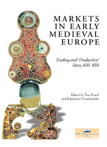
Front cover. The gold bow brooch found at Tjitsma in the
1950s. Total length 163.5mm. Collection Fries Museum,
Leeuwarden.
3.1 The principal ‘productive’ sites in Britain, as detailed in the
Appendix 22
3.2 Histogram comparing hoards and single-finds from England,
780–900 24
3.3a–c Finds from Hamwic, Tilbury and ‘near Royston’ 27
3.4a–c Finds from Bawsey, ‘South Lincolnshire’ and Hollingbourne 29
3.5a–c Finds from ‘near Malton’ 1, South Newbald and Whithorn 30
3.6 Isolated finds from England south of the Humber 32
3.7a–bFinds from London and Lincoln 33
4.1 Regression analysis showing the frequency of Hamwic coinage
within Wessex, mapped in contours 41
4.2 Regression analysis showing the proportion of primary
porcupine sceattas compared to all primary sceatta finds,
mapped in contours 42
4.3 Regression analysis of Type 15 secondary sceattas of ‘Hwiccian’
style, mapped in contours 44
4.4 Regression analysis of Series L sceattas, mapped in contours 46
5.1 Distribution map of sites in receipt of traded goods, based on
Palmer (1998) 49
5.2 Navigable rivers in England before the era of canals (after
Sherratt 1996) 52
5.3 Coin-productive sites (excluding hoards) and Roman roads in
Hampshire (after Ulmschneider 2000a, Map 21) 59
6.1 Some eighth- to eleventh-century finds from Meols (drawn by
Mark Faulkner) 67
6.2 Llanbedrgoch site plan (drawn by Tony Daly © National
Museums and Galleries of Wales) 70
7.1 The location and geography of the Isle of Wight 74
7.2 A simplified map of the geology of the Isle of Wight 77
vii
7.3 Coin-productive sites and markets around the Solent 79
8.1 Map of East Kent, showing the reconstructed coastline c. 800
and its relation to some of the sites and roads mentioned in
the text 87
8.2 Thiessen polygon interpolation, showing the environmental
pays of Kent and their relation to early estate-centres, as
defined by Everitt (1986) 89
8.3 Trend surfaces produced from the average number of
imported artefacts interred with each individual in Early
Anglo-Saxon cemeteries of East Kent 92
8.4 Trend surface of Early Medieval coin finds in East Kent 94
9.1 South-east Suffolk, showing the position of Barham and
Coddenham in relation to Ipswich, other Middle
Anglo-Saxon sites and the local system of Roman roads
(sources: Margary 1973; Moore 1988) 98
9.2 Barham, Suffolk, showing the distributions of artefact-types 100
9.3 Finds from Coddenham 105
9.4 Sceatta finds from Suffolk showing the number of coins
known from each site (source: Suffolk SMR) 107
10.1 Location map of sites discussed in Chapter 10 111
10.2 Bawsey: an aerial view of the site from the north-west.
(Photograph: D. A. Edwards, Norfolk Museums and
Archaeology Service) 113
10.3 Selected finds from Rudham 117
11.1 Locations mentioned in Chapter 11 123
11.2 (a) Bawsey and its surrounding parishes; (b) East and West
Rudham and surrounding parishes; (c) Hindringham and its
surrounding parishes 125
11.3 The parish church of Burnham Overy St Clement’s from the
south 127
12.1 Finds of Early Anglo-Saxon metalwork from Lincolnshire 139
12.2 Middle Anglo-Saxon finds from Lincolnshire and imported
material of similar date. Roman roads and early trackways
are shown as broken lines 141
12.3 Tenth-century and Viking metalwork shown against the
pattern of Middle Anglo-Saxon finds 142
12.4 Selected finds from Melton Ross 146
12.5 The site at Melton Ross 147
12.6 The combined parishes of Melton Ross, Barnetby le Wold
and the surrounding sites 148
12.7 The Yarborough Camp earthworks. Plan based on a survey
carried out by K. A. Leahy and J. C. Dyson in May 1984 150
Markets in
Early Medieval Europe
viii
13.1 The location of the sites at Cottam 156
13.2 The distribution of metal-detector finds (marked by crosses)
superimposed on crop-mark features of the Cottam B
enclosures 159
13.3 The Anglo-Scandinavian farmstead at Cottam B, seen as a
magnetometer plot 161
13.4 The distribution of lead weights, Norse bells, and other
objects attributed to the tenth century, superimposed on the
crop-mark enclosure and the suggested northward
settlement shift 162
13.5 The distribution of strap-ends 163
14.1 Markets and fairs in Norway and Sweden mentioned in
Chapter 14 169
15.1 The distribution of major ‘productive’ sites in Denmark and
southern Sweden. Sites mentioned in the text are numbered 177
15.2 Plan of the specialized production site at Næs on Zealand.
(after Møller-Hansen and Høier 2000, redrawn) 178
15.3 Plan of the Toftegård complex near Køge. (after Tornbjerg
1998, redrawn) 180
15.4 The manor complex from the seventh to tenth centuries at
Lejre with the residential area and workshop area to the east 182
15.5 Plan of one of the great halls in Lejre. (after Christensen 1997,
redrawn) 182
15.6 Map showing the archaeological status of the Tissø area in the
Viking period 184
15.7 The distribution of the c. 10,000 finds made at Tissø in the
metal-detector surveys and archaeological excavations 185
15.8 Distribution map showing the equal-armed brooches from the
middle of the sixth century (cross) and beaked brooches
(circle) from c. 600 186
15.9 Tissø: the excavated area with the manor dating from the
seventh to eleventh centuries and the adjacent market 187
15.10 A selection of the fine pendants, brooches and strap-mounts of
gilded silver and tin-plated bronze from the later manor at
Tissø. (Photographs: Pia Brejnholt) 188
15.11 A selection of arrowheads from the later manor at Tissø.
(Photograph: Danish National Museum) 189
15.12 Distribution map showing the weapons and weapon parts at
the Tissø complex 190
15.13 Coins from Tissø. (Photographs: Pia Brejnholt) 191
15.14 Distribution map of the coins at Tissø 192
15.15 The layout of the later manor at Tissø in Phase One,
preliminarily dated to the seventh to eighth centuries 193
Illustrations
ix
15.16 Tissø: the layout of the manor in Phase Two, preliminarily
dated to the eighth to ninth centuries 194
15.17 The layout of the manor at Tissø in Phase Three,
preliminarily dated to the ninth to tenth centuries 195
15.18 A selection of the Thor’s hammers and a miniature
strike-a-light from the later manor area at Tissø 196
15.19 Pendants depicting the valkyries of Norse mythology, in gilded
silver with niello inlays. (Photographs: Pia Brejnholt) 197
15.20 The layout of the manor at Tissø in Phase Four, preliminarily
dated to the late tenth to early eleventh centuries. The exact
size of the manor at this date cannot be determined 198
15.21 Plan of the hall area with the three main buildings in Phase
Four 199
15.22 Distribution map of the molten bronze and lead from
workshop activities at Tissø 200
15.23 (1)–(4) Three bronze and one lead model for the manufacture
of moulds for plate brooches and a cross-shaped brooch.
(Photographs: Pia Brejnholt) 201
15.24 Distribution map showing the weights at Tissø 202
15.25 A lead seal of the high-ranking Byzantine official Theodosios,
mid-ninth century. (Photograph: Danish National Museum) 203
15.26 Plan of the central representative area of Charlemagne’s Pfalz
in Aix, Germany. (after Hugot 1965, with additions by the
author) 205
16.1 Location of Groß Strömkendorf and other sites mentioned in
the text in relation to local topography 209
16.2 Overall plan of excavated areas with reconstruction of the
landscape to the west of the site. (Archäologisches
Landesmuseum Mecklenburg-Vorpommern, Schloß
Wiligrad, 19069 Lübstorf) 210
16.3 One part of the central area of the trading site showing the
careful alignment of pit-houses 211
16.4 Plan of the excavated area in the southern and central parts of
the site showing the dense occupation and selected
dendrochronological dates 214
16.5 Plan of the settlement structures within the area of the
cemetery and dendrochronological dates 214
16.6 Map showing the distribution of finds and archaeological sites
in the hinterland of Groß Strömkendorf. (after Schmitz
1999, Abb. 27) 218
17.1 The location of Tjitsma terp, Wijnaldum. (after Besteman, Bos
and Heidinga 1993) 222
17.2 Finds associated with precious metalworking. ( J. de Koning) 223
Markets in
Early Medieval Europe
x
17.3 Copper-alloy die stamp with cross-hatched decoration.
(Colin Slack, English Heritage) 224
17.4 Iron bars from Tjitsma. (after J. de Koning) 226
17.5 Assorted finds from Tjitsma. (all J. de Koning) 228
18.1 The ports of the Lower Seine in the ninth and tenth centuries 242
19.1 The location of San Vincenzo (a) and a plan of the site (b) 248
19.2 Site plan, showing the surveyed and excavated areas, and
prominent archaeological features, on the east bank of the
Volturno 251
19.3 Plan of the 1996–7 excavations 252
19.4 Early Medieval red-painted pottery from the excavations 253
19.5 Early Medieval glass-working crucibles from the excavations 254
19.6 Plan of Early Medieval clay-bonded structures, showing their
relation to the temporary workshops, prior to construction
of the atrium of San Vincenzo Maggiore 256
19.7 Plans of (a) the Early Medieval clay-bonded structures and
adjoining yards and (b) the so-called ‘collective workshop’ 259
Tables
12.1 The breakdown of Early Medieval metalwork recorded in
Lincolnshire to December 2000 140
12.2 The breakdown of metalwork from Melton Ross, by date 145
12.3 The breakdown of Anglo-Saxon and Viking metalwork from
Melton Ross, by type 145
15.1 Features appearing at both Tissø and a contemporary
Carolingian Pfalz 206
ادامه ...
بستن ...


